Here is my geology meme list! Bold the ones you have done (mine are in the comments).
1. See an erupting volcano (Mt St. Helens in summer 2006)
2. See a glacier (Glacier National Park and Sierras)
3. See an active geyser such as those in Yellowstone, New Zealand or the type locality of Iceland (Yellowstone in summer 2006)
4. Visit the Cretaceous/Tertiary (KT) Boundary. Possible locations include Gubbio, Italy, Stevns Klint, Denmark, the Red Deer River Valley near Drumheller, Alberta
5. Observe (from a safe distance) a river whose discharge is above bankful stage (A creek near my house in Jan 1997)
6. Explore a limestone cave (Several in the foothills in the Sierra, wild and by tours, Crystal Cave in Sequoia NP, and Lehman Caves in Nevada)
7. Tour an open pit mine, such as those in Butte, Montana, Bingham Canyon, Utah, Summitville, Colorado, Globe or Morenci, Arizona, or Chuquicamata, Chile (Round Mountain in Nevada)
8. Explore a subsurface mine (Sutter Gold mine in Sutter Creek, CA; mines outside of Ruth, NV)
9. See an ophiolite, such as the ophiolite complex in Oman or the Troodos complex on the Island Cyprus (The coast ranges of California)
10. An anorthosite complex, such as those in Labrador, the Adirondacks, and Niger (there's some anorthosite in southern California too)
11. A slot canyon, many of these amazing canyons are less than 3 feet wide and over 100 feet deep. They reside on the Colorado Plateau. Among the best are Antelope Canyon, Brimstone Canyon, Spooky Gulch and the Round Valley Draw
12. Varves, whether you see the type section in Sweden or examples elsewhere
13. An exfoliation dome, such as those in the Sierra Nevada (I like Turtleback dome in Yosemite, which give nice views of valley)
14. A layered igneous intrusion, such as the Stillwater complex in Montana or the Skaergaard Complex in Eastern Greenland (I have seen the Stillwater Complex in summer 2006)
15. Coastlines along the leading and trailing edge of a tectonic plate (I live in California)
16. A gingko tree, which is the lone survivor of an ancient group of softwoods that covered much of the Northern Hemisphere in the Mesozoic (I remember a bunch around my high school)
17. Living and fossilized stromatolites (Glacier National Park is a great place to see fossil stromatolites, while Shark Bay in Australia is the place to see living ones) (I have seen in the ones in Glacier National Park)
18. A field of glacial erratics
19. A caldera (Crater Lake National Park and Long Valley Caldera)
20. A sand dune more than 200 feet high (I have rolled down smaller dunes!)
21. A fjord
22. A recently formed fault scarp
23. A megabreccia
24. An actively accreting river delta
25. A natural bridge (Natural Bridges National Momument)
26. A large sinkhole (Does TV count?)
27. A glacial outwash plain
28. A sea stack (Nice ones along the California and Oregon Coast)
29. A house-sized glacial erratic (Out in Washington and Idaho)
30. An underground lake or river
31. The continental divide (Glacier National Park)
32. Fluorescent and phosphorescent minerals (some of my favorite samples are at a state mineral muesum in Mariposa, CA)
33. Petrified trees (Ginko Petrified Forest and some in Utah and Nevada)
34. Lava tubes (Of course, Lava Beds National Monument)
35. Grand Canyon, part way down and back (I have been out on the edge of Horseshoe Mesa)
36. Meteor Crater, Arizona, also known as the Barringer Crater, to see an impact crater on a scale that is comprehensible
37. The Great Barrier Reef, northeastern Australia, to see the largest coral reef in the world
38. The Bay of Fundy, New Brunswick and Nova Scotia, Canada, to see the highest tides in the world (up to 16m)
39. The Waterpocket Fold, Utah, to see well exposed folds on a massive scale (I was there this summer, swam in the Fremont River, and did a remote sensing project for one of my classes)
40. The Banded Iron Formation, Michigan, to better appreciate the air you breathe
41. The Snows of Kilimanjaro, Tanzania
42. Lake Baikal, Siberia, to see the deepest lake in the world (1,620 m) with 20 percent of the Earth's fresh water
43. Ayers Rock (known now by the Aboriginal name of Uluru), Australia. This inselberg of nearly vertical Precambrian strata is about 2.5 kilometers long and more than 350 meters high
44. Devil's Tower, northeastern Wyoming, to see a classic example of columnar jointing (Does Devils Postpile count?)
45. The Alps
46. Telescope Peak, in Death Valley National Park. From this spectacular summit you can look down onto the floor of Death Valley - 11,330 feet below (I have been to Augerberry Point)
47. The Li River, China, to see the fantastic tower karst that appears in much Chinese art
48. The Dalmation Coast of Croatia, to see the original Karst
49. The Gorge of Bhagirathi, one of the sacred headwaters of the Ganges, in the Indian Himalayas, where the river flows from an ice tunnel beneath the Gangatori Glacier into a deep gorge
50. The Goosenecks of the San Juan River, Utah, an impressive series of entrenched meanders
51. Shiprock, New Mexico, to see a large volcanic neck (only in the distance)
52. Land's End, Cornwall, Great Britain, for fractured granites that have feldspar crystals bigger than your fist
53. Tierra del Fuego, Chile and Argentina, to see the Straights of Magellan and the southernmost tip of South America
54. Mount St. Helens, Washington, to see the results of recent explosive volcanism (in 2003 and 2006)
55. The Giant's Causeway and the Antrim Plateau, Northern Ireland, to see polygonally fractured basaltic flows
56. The Great Rift Valley in Africa
57. The Matterhorn, along the Swiss/Italian border, to see the classic "horn" (How about the ride at Disneyland?)
58. The Carolina Bays, along the Carolinian and Georgian coastal plain
59. The Mima Mounds near Olympia, Washington (I have seen some in California, previous post)
60. Siccar Point, Berwickshire, Scotland, where James Hutton (the "father" of modern geology) observed the classic unconformity
61. The moving rocks of Racetrack Playa in Death Valley (I hope to soon)
62. Yosemite Valley (Numerous times)
63. Landscape Arch (or Delicate Arch) in Utah (I have been to both and wish I had more time to explore)
64. The Burgess Shale in British Columbia (I want to plan a trip soon)
65. The Channeled Scablands of central Washington (very cool)
66. Bryce Canyon (several different times)
67. Grand Prismatic Spring at Yellowstone
68. Monument Valley
69. The San Andreas fault (What part?)
70. The dinosaur footprints in La Rioja, Spain
71. The volcanic landscapes of the Canary Islands
72. The Pyrennees Mountains
73. The Lime Caves at Karamea on the West Coast of New Zealand
74. Denali (an orogeny in progress)
75. A catastrophic mass wasting event (Mt. St. Helens; rockslides in Yosemite Valley)
76. The giant crossbeds visible at Zion National Park
77. The black sand beaches in Hawaii (or the green sand-olivine beaches)
78. Barton Springs in Texas
79. Hells Canyon in Idaho
80. The Black Canyon of the Gunnison in Colorado
81. The Tunguska Impact site in Siberia
82. Feel an earthquake with a magnitude greater than 5.0 (Loma Prieta, 1989)
83. Find dinosaur footprints in situ
84. Find a trilobite (or a dinosaur bone or any other fossil) (Lots)
85. Find gold, however small the flake (been goldpanning)
86. Find a meteorite fragment
87. Experience a volcanic ashfall
88. Experience a sandstorm (Red Rock Canyon, Mojave Desert, summer 2003)
89. See a tsunami
90. Witness a total solar eclipse
91. Witness a tornado firsthand. (Important rules of this game)
92. Witness a meteor storm, a term used to describe a particularly intense (1000+ per minute) meteor shower
93. View Saturn and its moons through a respectable telescope
94. See the Aurora borealis, otherwise known as the northern lights
95. View a great naked-eye comet, an opportunity which occurs only a few times per century
96. See a lunar eclipse
97. View a distant galaxy through a large telescope
98. Experience a hurricane
99. See noctilucent clouds
100. See the green flash
Not bad with 45 completed, but there are still many more to go!
Monday, December 15, 2008
General meme list
Here is my general meme list. The idea is to bold the ones you've done (I'm also going to add commentary in parentheses).
1. Started my own blog (This one)
2. Slept under the stars (I slept on a cot when camping)
3. Played in a band (Not really any musical talent)
4. Visited Hawaii
5. Watched a meteor shower
6. Given more than I can afford to charity
7. Been to Disneyland/world
8. Climbed a mountain (I have climbed many and many more to go)
9. Held a praying mantis
10. Sung a solo
11. Bungee jumped (I want to!)
12. Visited Paris
13. Watched lightning at sea (Does Lake Tahoe count?)
14. Taught myself an art from scratch
15. Adopted a child
16. Had food poisoning (Luckily never!)
17. Walked to the top of the Statue of Liberty
18. Grown my own vegetables
19. Seen the Mona Lisa in France
20. Slept on an overnight train
21. Had a pillow fight (Many of sleepover when younger)
22. Hitchhiked
23. Taken a sick day when you're not ill (Always to do fun things)
24. Built a snow fort (Doesn't snow were I live )
25. Held a lamb
26. Gone skinny dipping
27. Run a Marathon (I want to)
28. Ridden in a gondola in Venice (All of the Italy and France items are on my list of items to do)
29. Seen a total eclipse (talk about it when I teach)
30. Watched a sunrise or sunset
31. Hit a home run (I played high school softball)
32. Been on a cruise
33. Seen Niagara Falls in person
34. Visited the birthplace of my ancestors ( I would have alot of countries to visit, which is ok with me)
35. Seen an Amish community
36. Taught myself a new language
37. Had enough money to be truly satisfied (you can be happy without money)
38. Seen the Leaning Tower of Pisa in person
39. Gone rock climbing
40. Seen Michelangelo's David
41. Sung karaoke
42. Seen Old Faithful geyser erupt (summer 2006)
43. Bought a stranger a meal at a restaurant
44. Visited Africa
45. Walked on a beach by moonlight (many beaches in California)
46. Been transported in an ambulance (I was really sick a few years back and actually had several different rides)
47. Had my portrait painted
48. Gone deep sea fishing (I am not patient enough for fishing)
49. Seen the Sistine Chapel in person
50. Been to the top of the Eiffel Tower in Paris
51. Gone scuba diving or snorkeling (Hawaii)
52. Kissed in the rain
53. Played in the mud (I love to be muddy)
54. Gone to a drive-in theater (there was a local theater)
55. Been in a movie (Does a homemade one count?)
56. Visited the Great Wall of China
57. Started a business
58. Taken a martial arts class (I have always want to)
59. Visited Russia
60. Served at a soup kitchen
61. Sold Girl Scout Cookies
62. Gone whale watching
63. Got flowers for no reason
64. Donated blood, platelets or plasma (I have voluntarily and not voluntarily)
65. Gone sky diving (I would like to)
66. Visited a Nazi Concentration Camp
67. Bounced a check (I think only twice)
68. Flown in a helicopter
69. Saved a favorite childhood toy
70. Visited the Lincoln Memorial
71. Eaten caviar
72. Pieced a quilt
73. Stood in Times Square
74. Toured the Everglades
75. Been fired from a job
76. Seen the Changing of the Guards in London
77. Broken a bone
78. Been on a speeding motorcycle (But I have been in many other speeding objects)
79. Seen the Grand Canyon in person
80. Published a book (How about I was an editor and wrote several sections)
81. Visited the Vatican
82. Bought a brand new car (My 2006 Subaru Forester)
83. Walked in Jerusalem
84. Had my picture in the newspaper
85. Read the entire Bible (Only parts of it)
86. Visited the White House
87. Killed and prepared an animal for eating
88. Had chickenpox (When I was in 1st grade)
89. Saved someone's life
90. Sat on a jury
91. Met someone famous (Does George Zimmer count?)
92. Joined a book club
93. Lost a loved one (my cat)
94. Had a baby (My son Justin is almost four)
95. Seen the Alamo in person
96. Swam in the Great Salt Lake
97. Been involved in a law suit
98. Owned a cell phone (Many, I keep breaking them)
99. Been stung by a bee (It stung me after I stepped on it)
100. Ridden an elephant
Looks like I still have many things to do!
Friday, December 12, 2008
The semester is over, but........

Well, I finished my advanced volcanology class last night, woohoo! Now, I have to patiently wait for my grades on my term paper and overall class. I also met with my advisor this morning since I wouldn't see her until after the new year. At this point in my graduate learning, I have completed some research, but mostly focused on taking classes and teaching. That is no longer the case, my six week vacation has now been determined for me. I must complete numerous research related items before school starts again on Jan 26. I know most of my days during this time will be spent tracing plagioclase like in the above picture and computer work involving the CSDCorrections program by Michael Higgins. This textural analysis program is downloadable for free at http://wwwdsa.uqac.ca/~mhiggins/home.html.
But first things first, I have a very large Christmas tree to decorate and then it is on to outlining!
Saturday, December 6, 2008
Out of the fog
 In my last entry, I was wanting to get out of the Central Valley fog and look for a sunny location. So I took a road trip to Yosemite on Thursday with my husband. The first picture is some mima mounds located near Snelling. Snelling is along the Merced River and I would say the dredge piles outnumber the people in town.
The next picture is along a road I have always wanted to take, but never did. The road climbs Mt. Bullion near Mariposa CA, is unmarked with many potholes and has some nice greenstone outcrops. In my mind, the best kind of road to take. It was also on this road that the sun was no longer hidden by fog.
 This is the Merced River Canyon and Highway 140. Where I live, it is about the same amount of time to take Highway 120 or Highway 140 to Yosemite, but the difference is the scenery along each. Highway 140 follows the Merced River to Yosemite Valley.
 This is the slate that lines the canyon, I believe it is part of the shoo fly complex (~500 mya)
Wednesday, December 3, 2008
Fog, more fog, and where is the sun?
 Living in the Central Valley of California is a wonderful thing, since the Sierras and Pacific Ocean are only a couple hours away by car. Wintertime is a different story with the tule fog. The fog stays for days at a time and becomes really depressing (i.e. the picture of my street). This week the fog has been around since the weekend. Atleast with rainstorm, you know that the sun will come out again, unfortunately with the fog that is unknown. I wish I could go take a drive up in the mountains to get away and bask in sunshine again, but I have some work to complete first. Possibly in the next few days, I will be able to get out and lose this depressive mood and get to use my hiking boots.
Monday, November 24, 2008
Remembering Field Camp.......

 I can't believe that I completed field camp over 4 year ago. The reason I bring up my field camp experience is my son turns 4 years old next month and I still shock myself that I completed field camp pregnant. I enjoyed my 6 week field camp with the University of Nevada, Reno, as it was my first time on the Colorado Plateau. The first two mapping projects were completed in Grand Staircase-Escalante National Monument along the Cockscomb monocline (the first and second photos). The Cockscomb fold consists of the Carmel-Page Formations, Entrada Sandstone, Tropic Shale, Dakota Sandstone, and Straight Cliffs. The trace of the fold can be driven on Cottonwood Road. We mapped for 9 days and stayed at Kodachrome Basin State Park. One day was designated for travel to Zion and Bryce Canyon National Parks, Cedar Breaks National Monument and Brian Head. The below photo is the view of Zion Valley from the 1/2 mile Canyon Overlook Trail. I was over 2 months pregnant at the time and remember feeling sick, but that did not stop me from hiking.
  Cedar Breaks National Monument consists mostly of the Clarion Formation, deposited as lake and river sediments around 50 my ago. Located on the side of the Markagunt Plateau, we arrived close to sunset, so the bright white and red rocks and associated hoodoos just absorbed the sun. The last photo is Grosvenor Arch located along Cottonwood Road. It was the first arch I had ever seen.
Hatfield et al., 2003, Geology of the Cedar Breaks National Monument, Utah; in Geology of Utah's Parks and Monuments, 2003 Utah Geological Association Publication 28, 562 p.
Friday, November 21, 2008
Sacramento State Rock Auction

I finished my big paper on magma mixing and crystal size distributions for my advanced volcanology class yesterday, yeah! So tonight I am going to reward myself by attending the rock auction the Geology Club has been hosting the last five years. Geology club members contact local geologists, rock shop owners, and anyone else who will donate rocks, fossils and minerals. The event has a live auction and silent tables. The auction is an excellent way to raise money to help students pay for field trips and computer lab supplies. Which brings me to, I finished reading a great fossil book, Cruisin' The Fossil Highway, by Kirk Johnson and Ray Troll. They state a condition called IPNS or Isolated Paleonerd Syndrome. I do not have a full blown case of IPNS, but I would like to think I have a minor case. I tend to focus on fossils at rock shops much longer than minerals and I am really hard to drag away from a fossil hunting site. Even the above picture is one of two fossil ferns slabs I bought at the rock auction two years ago.
Tuesday, November 11, 2008
Wild Animals in the Field


 Ok, so they are not your typical wild animals, but I realized that I do not have many pictures of any kind of animals. My first photo is from the parking lot at Logan Pass in Glacier National Park. I love the Going to the Sun Highway! My second photo is from my first field mapping project at Red Red Canyon State Park, CA. My third photo is from my structural field mapping class to the Poleta Folds in the White Mountains. My fourth photo is from a limestone cave in the mother lode of the Sierra Nevada. My last photo is from Lake Tahoe while listening to a lecture during field camp with UNR.
Friday, November 7, 2008
Using Clean Natural Resources
 For my advanced volcanology class, we were encouraged by my professor to attend a Volcanological Society of Sacramento (VSSAC) meeting. Of course, he is one of the head members of the organization and the meeting meets on the second floor of the geology building on campus. The presentation was given by a geologist named Tom Box. He gave a wonderful talk, The Nature, Development, and Preservation of a Unique Resource on "The Geysers". If "The Geysers" are unknown to you, it is the world's largest producing geothermal plant and is located near prime wine country in the California Coast Ranges. He was a on-site geologist for several decades. The geothermal area was found in the late 1840's and used as a destination resort for many years. Commerical steam power started slowly in the 1960's, didn't become a big producer until the 1970's, and reached its peak in the 1980's. Currently, the plant has a extensive ground water injection program, which might explain the continuous microquakes in the area (see diagram above, cluster of small earthquakes outlines "The Geysers" region).
Other geothermal plants in California include locations at the Salton Sea and Coso Volcanics.
I really enjoyed the talk and greatly improved my knowledge of geothermal power as a clean natural resource. This presentation brought to my mind, we as a society need to focus on alternative resources, instead of beating around the "bush" for more decades by using coal and foreign oil.
Tuesday, November 4, 2008
More High Rock Caldera
 Here is the Google Earth image of the High Rock Caldera. I put the detailed directions (the way we took) of the little white path on the image in the comment section of a previous blog entry, High Rock Caldera.....almost.
Change can begin now
This afternoon when I casted my vote, it was for the winning candidate and I can say I am happy about that! My polling place only had a short line when I went to vote, but I voted around 10:30AM. I was taking a break from my massive stack of journal articles I have been reading. I have a first draft of a paper in my advanced volcanology class due in a little over a week. Luckily my topic is about some work I have completed so far for my masters thesis. That is were the luck stops, because I have some sections of the paper completed, but other sections need to be vastly improved, so that's were the big stack of papers rears its ugly head! All of the papers I have read in the last three days are on magma mixing and enclaves. I still probably have several more days of reading with a equally large stack of crystal size distribution papers to get through. So I am defiantly going to be busy the next week or so, woohoo!
Here is a sampling of some of the papers I have read. My list could be much longer, but I don't want to bore you.
Bacon, C.R., 1986, Magmatic Inclusions in Silicic and Intermediate Volcanic Rocks: Journal of Geophysical Research, v. 91, p. 6091-6112.
Browne, B.L., J.C. Eichelberger, L.A. Patino, T.A. Vogel, J. Dehn., K. Uto, and H. Hoshizumi, 2006, Generation of Porphyritic and Equigranular Mafic Enclaves during Magma Recharge Events at Unzen Volcano, Japan: Journal of Petrology, v. 47, p. 301-38.
Eichelberger, J.C., 1980, Vesiculation of mafic magma during replenishment of silicic magma reservoirs: Nature, v. 288, p. 446-450.
Koyaguchi, T., 1985, Magma mixing in a conduit: Journal of Volcanology and Geothermal Research, v 25, p. 365-369.
Martin, V.M, D.M. Pyle, and M.B. Holness, 2006, The role of crystal frameworks in the preservation of Enclaves during magma mixing: Earth and Planetary Science Letters, v. 248, p. 787-799.
Sparks, R.S.J., H. Sigurdsson, and L. Wilson, 1977, Magma mixing-a mechanism for triggering acid explosive eruptions: Nature, v. 267, p. 315-318.
Monday, November 3, 2008
High Rock Caldera.....almost
 Finally, northwestern Nevada and in the distance is the rim of the approximately 16 million year old High Rock caldera, but that is as far as I would get. The problem traveling in school owned vehicles is that they are always 2wd drive vans. The snow was from the first big storm of the season several weeks back and it was decided that we would not take to take the van into snow country, seeing if we got stuck, we would be stuck for awhile. Plus there was going to be an increase in elevation and the group decided, we had never camped in snow, why start now!
 But not being able to get to the caldera was not entirely bad. While stopped to figure out if the road was passable or not, lying on the ground in incredible amounts were dull red rounded rocks, when broken exposed the most beautiful obsidian I have ever seen.
 Which then made everyone forget about how cold it was outside and like kids in a candy store, search for the obsidian "eggs". See how excited grad students can get about rocks!
 I found my share of good "eggs" and decided to photograph the snow and scenery, in which I quickly got hounded for. I also couldn't resist my urge for sneak snowball attacks and to build a snowman, no matter how big it was, only a ft tall.
 So it was on to Plan B........
 Monday, October 27, 2008
Interesting tree.....?


Joining in on the mini-meme about trees. I thought about what beautiful trees I could think of off the top of my head. I love the ancient bristlecone pines, the tall coastal redwoods, the valley oaks and the massive sequoias, but this one tree along Highway 50, is the first tree that came to mind. It is not beautiful but interesting and is dubbed "The shoe tree". I first came upon this tree in 2004 during my field camp days at UNR. What would cause people driving, to pick this one random tree in the middle of Nevada to stop and throw a pair of old shoes within its branches? My first thought is that non geologists get bored traveling along the highway, which in no way is boring to a geologist. There is not many trees along this stretch of road in Nevada, so why damage the only shade for miles. My reasoning on why people can do something like this turn into puzzling and angry thoughts, it shows the great American way, if one person does it then another must and then another until you have a tree full of old shoes. This is disrespecting nature and in my views not needed, I don't care if is it in the middle of nowhere or next door to my house.
Also a natural history stop
Prisoners Rock is also known as Petroglyph Point and is protected as a small portion of Lava Beds National Monument. The below picture is the western cliff of the tuff cone that reveals numerous wave cut benches that formed when Tule Lake (Modoc Lake) was at a higher level. The Tule Lake basin was filled with water until 1905, after which the lake was drained for agricultural use. Also in the picture is the fence that protects the petroglyphs from being defaced.


 Tread lightly if ever visiting Prisoners Rock or

There are over 5,000 different petroglyphs that date around 4,500 to 2,500 years ago. So why the petroglyphs at this locations and who completed the rock art? It is believed that the Modoc people used canoes to cross Tule Lake to the island and then complete the petroglyphs unlike other Great Basin rock art. Below are some of my favorite petroglyphs.

 Tread lightly if ever visiting Prisoners Rock or
"Someday Kamookumpts will surely wake up and look out over the world he made. He may be angry at how things have changed and bring the water back to cover Tule Lake again, changing the world to be like it was when he first made it."
Sunday, October 26, 2008
Tuff Cones!
The photos in today's blog are my traverse on top of Prisoners Rock.
 This photo shows some of the palagonitic rock (orange rust color). Palagonite is a hydration and oxidation of volcanic rocks.
 This is the view across the entire tuff cone. The vent area is buried somewhere out in the middle.
 This is a piece of juvenile lava that was erupted out. When dealing with phreatic eruptions, it sometimes is problematic to determine if the lava erupted is juvenile or non juvenile. A clue is that juvenile lava is very fragile and has a cauliflower texture.
 This is a view to the north showing The Peninsula, a bigger tuff cone in the distance.
 Here is the entire view of The Peninsula. It is roughly the same age as Prisoners Rock, but once the tuff cone was above lake level, a small lava lake formed and is represented by the small ledge in the left middle of the photo.
Friday, October 17, 2008
It was cold!
Like I said in the previous post, I knew it was going to be cold on my trip and indeed it was! The advanced volcanology class had to arrive at the Devils Homestead flow lookout in Lava Beds National Monument by Saturday noon, which meant me leaving Modesto at 4AM to get to Sacramento by 5:30AM and after we got the van packed, we left Sac State at 6AM. Traveling by Interstate 5 to Weed, because I was map girl and instructed we could not go over the Medicine Lake Highland. Mt. Shasta was beautiful with a fresh covering of snow and surrounded by clouds. MacDougal and Dorris on Highway 97 are unchanged. There wasn't many birds in the Klamath Basin Preserve, but of course it was hunting season, so I would want to be there either! Arriving in Lava Beds around 11AM and not able to find the undergrad volcanology class (we actually did look), we went to the visitor center, but having been an organizer for a conference last fall at Lava Beds I was wanting to wonder around. The biggest change I noticed was that Cave Loop road was closed from sunset to 8AM, but I was so tired, I didn't get to do any lava tubing.
 The undergrads found us and they were sent home and our field trip started. We spent the rest of the day at Prisoners Rock (also called Petroglyph Point for thousand of petroglyphs that are present). Prisoners Rock is a tuff cone that formed approximately 270,000 years ago. Types of hydrovolcanic deposits include armored lapilli (second photo), beds dipping 25-40 degrees from the vent area, lithic clasts, juvenile lava, and massive deposits (fourth photo). The third photo is an interesting feature that was unknown to any of us and not described in any papers we had with us.


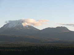
 It was very windy and a little cold, but I could of been warmer because I was only wearing a pair of workout pants. It got in the lower 20's for the night. The weather made me sleep in a tent for the first time in several years and I was glad I bought it. I had three blankets, lots of heat warmers and a nalgene bottle with hot water at the bottom of my sleeping bag. It was the best I had ever slept in cold weather. So I will leave you with a photo of a freshly covered Mt. Shasta from on top of Prisoners Rock.

 The undergrads found us and they were sent home and our field trip started. We spent the rest of the day at Prisoners Rock (also called Petroglyph Point for thousand of petroglyphs that are present). Prisoners Rock is a tuff cone that formed approximately 270,000 years ago. Types of hydrovolcanic deposits include armored lapilli (second photo), beds dipping 25-40 degrees from the vent area, lithic clasts, juvenile lava, and massive deposits (fourth photo). The third photo is an interesting feature that was unknown to any of us and not described in any papers we had with us.

 It was very windy and a little cold, but I could of been warmer because I was only wearing a pair of workout pants. It got in the lower 20's for the night. The weather made me sleep in a tent for the first time in several years and I was glad I bought it. I had three blankets, lots of heat warmers and a nalgene bottle with hot water at the bottom of my sleeping bag. It was the best I had ever slept in cold weather. So I will leave you with a photo of a freshly covered Mt. Shasta from on top of Prisoners Rock.
Friday, October 10, 2008
I will be on the road again this weekend....
but I am going to freeze my behind off! My advanced volcanology class is taking a trip to Lava Beds National Monument-Tule Lake basin area and High Rock Caldera in northwest Nevada. The caldera is suggested to be the oldest volcanic area in the Yellowstone hotspot track, so that basically means it is out in the middle of nowhere and has not been studied very much. I just was checking temperatures, it is going to be a nice warm toasty 50 degrees in the daytime and 20 degrees at night. At least we will have a lot of firewood! The focus of the trip is hydrovolcanism, so I when I get back I hope to post a bunch of interesting photos, that is if we aren't frozen to the Nevadan high desert!
Wednesday, October 8, 2008
"In Search of the Old Ones"


 In Search of the Old Ones is a book by David Roberts that I am currently reading. I am really enjoying the book, he shares his experiences of traveling the southwest looking for Anasazi sites and understanding their culture. Some influential people in locating Anasazi sites were the Wetherill brothers. They found sites like Cliff Palace in Mesa Verde and Chaco Canyon in New Mexico, but they are many other important archaeological sites of the Anasazi that are just important, for instance the Grand Gulch area of Cedar Mesa.
Which brings me to my photos. In a previous entry, I said that Cedar Mesa was one of my favorite places I traveled to this summer in my southwest journeys. After spending the night on the mesa at Muley Point, one of the planned stops the next day was Mule Canyon. Located on the northeast side of the mesa, this was my first chance to see ruins not in a touristy nature like Spruce Tree House at Mesa Verde. The above photos are some of the Anasazi ruins located in the North Fork of Mule Canyon.
I am looking forward to the time I can travel back to the area and do more exploring and learning about the Anasazi.
Tuesday, October 7, 2008
Hydrovolcanism within the Mono Basin


On my eastern Sierra trip, I saved the best hydrovolcanism for last. Mono Lake is a remnant of Pleistocene age Lake Russell. If you are a bird watcher, the lake is an important pit stop for birds on the flyway and three times saltier than the ocean. Over 13,000 years ago the lake was more than 800 ft deeper than present when Black Point (second photo) erupted. Black Point received its name for obvious reasons since it produced basaltic lava. I wish I had time to venture out to the area, but I did not. So I will just have to make another trip to see the fissures and palagonitic soil.
The current lake level is regulated because starting in 1941, the Los Angeles Department of Water and Power (LADWP) began diverting water from streams that filled the lake, this dropped the lake level dramatically, enough so to damage the gull population at the lake. So to make a long story short, LADWP, must now allow some water to be released back into the lake. For the full story, I recommend the book, Storm over Mono Lake, by John Hart. Instead my focus on Mono Lake for this blog entry is Paoha and Negit Islands. Negit Island (photo 3) is a 1,600 year old andesitic volcano that has had activity as recently as 270 years ago. Paoha Island (photo 4) is problematic, made up of lake mud sediments, it may be a bulge from unerupted magma or could have been caused by local faults in the area. Anyways, it dates around 300 years old.
My first photo is Panum Crater, the youngest volcano in the Mono Craters chain that erupted around 600 years ago. It is a type of volcano known as a tuff ring. Usually tuff rings are monogenetic but the geologic history of Panum Crater is more complex. The eruption started with a tuff ring, then a dome was built, but collapsed sending a debris avalanche into Mono Lake, then a second dome formed. In my photo, I show the place where the dome collapsed through the tuff ring into the lake. If ever in this area, there is a short trail that can be taken to the top of Panum Crater. The reward is great views of Mono Lake, the Mono Craters and the June Lake/Mammoth Lakes Area and a hike through obsidian.
Also recommended when in Lee Vining is the Mono Lake Committee store and the National Forest Visitor Center, which has great exhibits on Mono Lake and a balcony to view the lake. If hungry when passing through and wanting an old style burger or ice cream cone, eat at the Mono Cone. If gourmet food is in order, then stop at the Whoa Nelli Deli, try the fish tacos, they are tasty.
Wednesday, October 1, 2008
Class Project: Hydrovolcanism on the East side of the Sierra
After enjoying geologic sites around Mammoth Mountain, the main purpose of my trip was to add photos of hydrovolcanism. Below is a Google Earth map showing the relationship between the Inyo Craters and Mammoth Mountain. Mammoth Mountain is in the southwest corner covered with ski trails and the Inyo Craters are the two little lakes located near the top middle part of the map. So why did I want pictures of the Inyo Craters for my class presentation? The Inyo Craters are a type of hydrovolcanism known as phreatic eruptions that produce structures called maars.
 The below picture is the biggest of the three maars that comprise the Inyo Craters. The size of the crater is 600 ft wide and 200 ft deep and there is a permanent lake at the bottom of the crater. The second maar is just a little to the northeast and not quite as wide and 100 ft deep. The third maar is located on top of Deer Mountain. A maar forms when magma comes in contact with groundwater and produces violent steam explosions. Magma never reaches the surface, but the result of the steam explosion leaves a sizable crater. The eruptive phase tends to last anywhere from days up to a month. The Inyo Craters are some of the youngest volcanic features in California erupted around 550 years ago. A shallow dike is the most likely cause for the eruptions.
 The next photo reflects the type of deposits that are deposited by a phreatic eruption. These deposits are coarsely layered and exhibit poor sorting of ash to gravel size. In phreatic eruptions it is hard to determine juvenile magma, because the steam eruption will also cause non juvenile clasts to be ejected.
 This photo shows the northeast trending relationship of all three craters, but the third crater is hidden in the trees on top of Deer Mountain. The craters are believed to have erupted in sequence from north to south.
 Below is the deposits of the second biggest crater. Distinct characteristics exist between the two maars other than size. The second maar contains a smaller lake and mature trees located within the crater.
 The craters are that way! This is the trail marker at the end of the 1.2 mile dirt road. To get to the Inyo Craters: take the Mammoth Lakes Scenic Loop and travel several miles and look for the Inyo Craters sign, turn left if coming from Mammoth Mountain and follow the signs to the craters. There are many dirt trails that you could potentially get lost, always choose to the right.

 The below picture is the biggest of the three maars that comprise the Inyo Craters. The size of the crater is 600 ft wide and 200 ft deep and there is a permanent lake at the bottom of the crater. The second maar is just a little to the northeast and not quite as wide and 100 ft deep. The third maar is located on top of Deer Mountain. A maar forms when magma comes in contact with groundwater and produces violent steam explosions. Magma never reaches the surface, but the result of the steam explosion leaves a sizable crater. The eruptive phase tends to last anywhere from days up to a month. The Inyo Craters are some of the youngest volcanic features in California erupted around 550 years ago. A shallow dike is the most likely cause for the eruptions.
 The next photo reflects the type of deposits that are deposited by a phreatic eruption. These deposits are coarsely layered and exhibit poor sorting of ash to gravel size. In phreatic eruptions it is hard to determine juvenile magma, because the steam eruption will also cause non juvenile clasts to be ejected.
 This photo shows the northeast trending relationship of all three craters, but the third crater is hidden in the trees on top of Deer Mountain. The craters are believed to have erupted in sequence from north to south.
 Below is the deposits of the second biggest crater. Distinct characteristics exist between the two maars other than size. The second maar contains a smaller lake and mature trees located within the crater.The craters are that way! This is the trail marker at the end of the 1.2 mile dirt road. To get to the Inyo Craters: take the Mammoth Lakes Scenic Loop and travel several miles and look for the Inyo Craters sign, turn left if coming from Mammoth Mountain and follow the signs to the craters. There are many dirt trails that you could potentially get lost, always choose to the right.
Subscribe to:
Posts (Atom)
