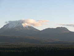
After enjoying geologic sites around Mammoth Mountain, the main purpose of my trip was to add photos of hydrovolcanism. Below is a Google Earth map showing the relationship between the Inyo Craters and Mammoth Mountain. Mammoth Mountain is in the southwest corner covered with ski trails and the Inyo Craters are the two little lakes located near the top middle part of the map. So why did I want pictures of the Inyo Craters for my class presentation? The Inyo Craters are a type of hydrovolcanism known as phreatic eruptions that produce structures called maars.

The below picture is the biggest of the three maars that comprise the Inyo Craters. The size of the crater is 600 ft wide and 200 ft deep and there is a permanent lake at the bottom of the crater. The second maar is just a little to the northeast and not quite as wide and 100 ft deep. The third maar is located on top of Deer Mountain. A maar forms when magma comes in contact with groundwater and produces violent steam explosions. Magma never reaches the surface, but the result of the steam explosion leaves a sizable crater. The eruptive phase tends to last anywhere from days up to a month. The Inyo Craters are some of the youngest volcanic features in California erupted around 550 years ago. A shallow dike is the most likely cause for the eruptions.

The next photo reflects the type of deposits that are deposited by a phreatic eruption. These deposits are coarsely layered and exhibit poor sorting of ash to gravel size. In phreatic eruptions it is hard to determine juvenile magma, because the steam eruption will also cause non juvenile clasts to be ejected.

This photo shows the northeast trending relationship of all three craters, but the third crater is hidden in the trees on top of Deer Mountain. The craters are believed to have erupted in sequence from north to south.

Below is the deposits of the second biggest crater. Distinct characteristics exist between the two maars other than size. The second maar contains a smaller lake and mature trees located within the crater.

The craters are that way! This is the trail marker at the end of the 1.2 mile dirt road. To get to the Inyo Craters: take the Mammoth Lakes Scenic Loop and travel several miles and look for the Inyo Craters sign, turn left if coming from Mammoth Mountain and follow the signs to the craters. There are many dirt trails that you could potentially get lost, always choose to the right.

 The below picture is the biggest of the three maars that comprise the Inyo Craters. The size of the crater is 600 ft wide and 200 ft deep and there is a permanent lake at the bottom of the crater. The second maar is just a little to the northeast and not quite as wide and 100 ft deep. The third maar is located on top of Deer Mountain. A maar forms when magma comes in contact with groundwater and produces violent steam explosions. Magma never reaches the surface, but the result of the steam explosion leaves a sizable crater. The eruptive phase tends to last anywhere from days up to a month. The Inyo Craters are some of the youngest volcanic features in California erupted around 550 years ago. A shallow dike is the most likely cause for the eruptions.
 The next photo reflects the type of deposits that are deposited by a phreatic eruption. These deposits are coarsely layered and exhibit poor sorting of ash to gravel size. In phreatic eruptions it is hard to determine juvenile magma, because the steam eruption will also cause non juvenile clasts to be ejected.
 This photo shows the northeast trending relationship of all three craters, but the third crater is hidden in the trees on top of Deer Mountain. The craters are believed to have erupted in sequence from north to south.
 Below is the deposits of the second biggest crater. Distinct characteristics exist between the two maars other than size. The second maar contains a smaller lake and mature trees located within the crater.

No comments:
Post a Comment