


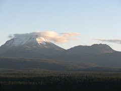
Well, we made it to the top! As I said in the last post, I completed the 2.5 miles in 1.5 hours. I love testing my body hiking. I am not in perfect shape, but I can hold my own. So all of today's pictures were taken along the trail at various locations. The trail starts out in pine trees, then the trees get smaller, and then there is no plant life at all. The first picture is the north facing barren slope of Lassen Peak. The barren slope is evidence from the 1915 eruptions that caused the Devastated Area (see previous post). Lenticular clouds are also very interesting and make great contrast for the picture.
The second picture was taken to the southwest and has a view of Brokeoff Mountain. Brokeoff Mountain is actually a remnant of Brokeoff volcano ( I have also heard it called Mt. Tehama) that started forming over 600,000 years ago. The volcano was estimated to be 12 km in radius, over 3350 m high, and have a reconstructed volume of 80 km3. The andesitic volcano has been eroded over time by volcanic processes and glaciers (Clynne, 1990).
The third picture exhibits prismatic jointing in the rock and is just interesting to me. The last picture is Me and Melinda on top. We are just two friends enjoying the experience!
Next blog, pictures of the May 19, 1915 lavas.
Clynne., M.A., 1990, Straitgraphic, Lithologic, and Major Element Geochemical Constraints on Magmatic Evolution at Lassen Volcanic Center, California; Journal of Geophysical Research, v. 95, 19651-19669.

No comments:
Post a Comment