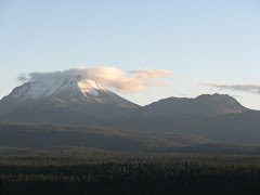
 So for my last day of my field work, I decided that I would not try to hike to Domes A, B and C, seeing I was tired from the previous two days and instead climb Lassen Peak to get an aerial view of the Chaos Crags. It is no means an easier hike, it is actually harder, and I know I can get aerial images from Google Earth, but the excitement is not as great as climbing one of the world's largest volcanic domes in 1 and half hours!
The view above is Lassen Peak from the Devastated Area (northeast of the volcano), named for the mud flow, avalanche, and pyroclastic flow that was released during explosive events on May 19 and 22, 1915. Luckily, no one was killed during these events, but several houses were destroyed along Hat Creek. From prolonged volcanic activity starting in 1914 and lasting to 1917 and the striking natural beauty of the area, Lassen Volcanic National Park was created in 1916.
 The above picture is the black dacite lava flow that was erupted on May 19, 1915. This picture was a telephoto shot from the Devastated Area. The flow is more prominent on the southwest side of the volcano.
 This feature located on the side of Lassen Peak is just interesting to me. It is called the Vuclan's Eye (this is for the Star Trek fans). I don't know the whole story on how it formed, it looks like some kind of prismatic jointing to me. Any guesses?
So we begin an epic journey up the 2.5 mile trail and over 2,000 ft of evelation gain. This was the second chance I had to hike the trail, but the first chance with amble time to do so. If you ever end up in Lassen Volcanic National Park, Lassen Peak is one of those must do hikes!

No comments:
Post a Comment